The Trail
Discover one of Tasmania's hidden gems - The North East Rail Trail.
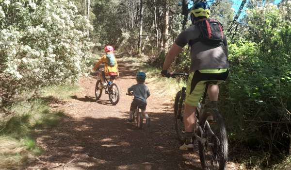
Step into a world of natural beauty and quiet adventure on the North East Rail Trail. This picturesque trail offers an easy, family-friendly ride through Tasmania’s stunning north-east countryside following the path of the old railway line.
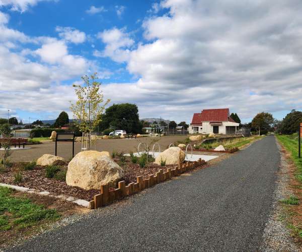
Start your adventure at Scottsdale - the major regional centre of the North East. Here there are plenty of accommodation options including free camping at Northeast Park, supermarkets, a micro brewery, bakery, and numerous cafes with some great coffee and tasty local treats on offer to start your adventure.
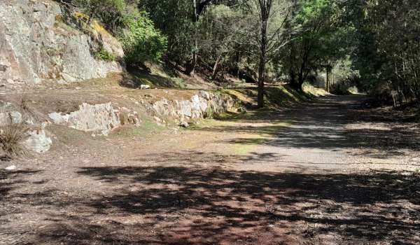
The trail officially commences at the old Scottsdale Railway Station where it heads south out of town and descends through picturesque farmland and bushland. A trail connection links 3km out of town with Northeast Park for those camping or wanting a small detour. Heading behind the old timber mill at Lings Sidling the trail crosses the Tasman Highway twice (good sight lines) before crossing over the Great Forester River at Tonganah.
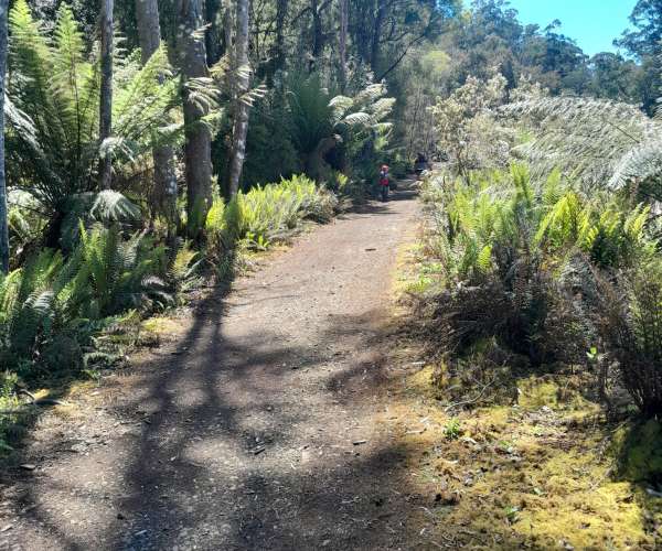
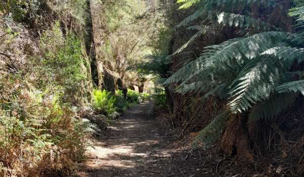
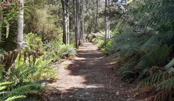
From Tonganah the trail heads steadily up through tall forests, tree fern lined cuttings and huge embankments across gullies to the former railway station at Tulendeena (the top of Billycock Hill). Here the trail officially ends, however, you can continue down the Snake Track into Legerwood (approximately 3.4km) to see the historical tree carvings. (Note: This road is gravel and steep in places).
Whether you are cycling, walking or just soaking in the serene landscapes, the trail delivers a unique and picturesque experience with the perfect blend of adventure and relaxation.
The trail itself is two directional and consists of a good gravel surface, suitable for all weather riding. It is family-friendly, rich with wildlife, and dotted with opportunities to learn more about the history of the area, Whether you are a weekend explorer or a seasoned cyclist, the North East Rail Trail invites you to slow down and connect with nature - one peaceful kilometre at a time.
Ride. Relax. Rediscover.
Trail Essentials
Length: 26km (one way) - shorter rides available.
Time: Allow 2-4 hours cycling, 6-8 hours walking
Access: Multiple entry points—Scottsdale, Tonganah and Tulendeena
Facilities: Picnic shelters, rest stops, toilet, and interpretative points along the way.
Surface: Mostly compacted gravel - all weather trail.
Gradient: Gentle grades (maximum 3%), suitable for most fitness levels
Be prepared: Tasmania is known for its “four seasons in one day” so be prepared and carry water, sunscreen and appropriate clothing and gear for all weather conditions regardless of the time of year. A bike repair kit is essential for emergencies.
Check Tasmania Fire Service for up to date fire danger ratings, fire ban information and current incidents and warnings that may affect the trail.
Private property: Stay on the trail and respect adjoining private land
Leave no trace: Take only photographs, leave only footprints. Dispose of waste properly – pack it in, pack it out.
Respect other users: Keep left, signal when passing and share the trail
Respect wildlife: Observe quietly, do not feed or chase animals.
You may encounter native animals along the trail: Wallabies, pademelons and echidnas may cross unexpectedly, especially at dawn and dusk. Snakes are sometimes seen sunning themselves on warm days—leave them alone, give them space and they will move away.
Dogs: Dogs should be on lead.
Trail Facilities
Shelters are located at the old railway station sites at Trewalla, Kamona and Tulendeena.
Toilet facilities are located at: Scottsdale - Alfred Street (next to the Scottsdale Visitor Information Centre), Northeast Park, Tonganah (Don's Dunny) and Legerwood (Legerwood Park)
BBQ facilities are available at: Scottsdale (Northeast Park and Children's Reserve) and Legerwood Park, Legerwood.
Water is available at: Scottsdale - Railway Precinct and Tonganah.
Camping is available at: Scottsdale - Northeast Park and Legerwood Park, Legerwood.
Parking is available at the Scottsdale Railway Precinct (Ellenor Street), Northeast Park, Tonganah (Don's Dunny), Tulendeena (opposite trail entrance) and Legerwood Park.
Trail Sections (Shorter rides)
Scottsdale to Northeast Park - 3km
Around 3km (one way) takes you to Northeast Park, where you’ll find walking trails, BBQ facilities, a playground and amenities. From there, you can return to Scottsdale via the trail or do a loop back into town along Ringarooma Road (Tasman Highway).
To find Northeast Park take the A3 (Ringarooma Road/Tasman Highway) out of Scottsdale towards Derby. Approximately 1km out of town you will find Northeast Park on the right.
Scottsdale to Don's Dunny (Tonganah) - 9km
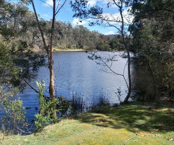
About 9km (one way) from Scottsdale, you’ll come across Don’s Dunny. Just another 800m along is the old Tonganah Clay Mine, with tranquil grassy areas by the water — an ideal spot for a picnic. You can either ride back to Scottsdale or arrange a pick-up at the end of Tonganah Road.
To find Don's Dunny take the A3 (Tasman Highway) out of Scottsdale towards Derby. Approximately 7km turn right onto Tonganah Road and follow the signs.
Don's Dunny (Tonganah) to Kamona Station - 12km
Considered by many the most picturesque section of the trail, this 12km (one way) ride or walk showcases some of the rail trail’s most stunning scenery. Kamona Station provides a picnic shelter nestled in tranquil forest surrounds, while a conveniently located shelter at the 6km halfway point (Trewalla Station) makes it perfect for a full day out.
To find Don's Dunny take the A3 (Tasman Highway) out of Scottsdale towards Derby. Approximately 7km turn right onto Tonganah Road and follow the signs.
Tulendeena (Billycock Hill) to Tonganah - 16km
At approximately 16km (one way), this ride is all downhill and the perfect choice if you haven't the time (or legs) for the full trail! Arrange a drop-off at Tulendeena (Billycock Hill) and enjoy a relaxed ride or walk through the forest. Pause for a picnic at the old Kamona railway station, where a shelter provides a comfortable place to rest and take in the surroundings. Continue downhill through what is arguably the most scenic section of the trail, finishing beside the picturesque Tonganah Clay Mine at another excellent picnic spot. Arrange a pick up at Don's Dunny (800m further down the trail) or return back uphill through the forest to Tulendeena.
To find Don's Dunny take the A3 (Tasman Highway) out of Scottsdale towards Derby. Approximately 7km turn right onto Tonganah Road and follow the signs.
Trail Maintenance
The trail corridor is jointly managed by Dorset Council and Scottsdale Rotary Club with Dorset Council maintaining the trail from Scottsdale to Tonganah and Rotary volunteers maintaining the trail from Tonganah (Don's Dunny) to Tulendeena. Both Dorset Council and the Rotary Club, through proceeds raised from their annual Rail Trail Run and Ride event, contribute funding that is reinvested into the ongoing maintenance and improvement of the trail.
If you come across something needing attention on the trail:
Any maintenance or management matters concerning the Scottsdale to Tonganah section of the rail trail should be directed to Dorset Council via: https://www.dorset.tas.gov.au/contacts.
Any maintenance or management matters concerning the Tonganah to Tulendeena section of the rail trail should be directed to Rotary. Call Shane on 0409 527 228.
Trail History
The Launceston to Scottsdale railway line was opened in February 1889 with the rail reaching Branxholm in 1911 and to Herrick in 1919. By the 1960's the line usage began to decline with increased road transport and by 1978 the last passenger trains closed down in Tasmania and the rail network, including the Launceston-Scottsdale line, focused solely on freight. By the early 1980's the Scottsdale line had just three daily services, by 1994 the line between Herrick and Tonganah was closed and by 2005 the line was closed to freight services.
Stage 1: Tonganah to Tulendeena - 16km - OPEN
Stage 2: Tonganah to Scottsdale - 10km - OPEN
The Rotary Club of Scottsdale and volunteers developed the first 14km section of the trail from Tonganah through to Billycock Hill. This was opened around 2012 with the second stage from Scottsdale to Tonganah opened in 2015.
Stage 3: Scottsdale to Lilydale Falls - 40km - PLANNING
Stage 3 of the trail is currently in the planning phase and will see an additional 40km of trail constructed to connect Scottsdale through to Lilydale Falls Reserve.
Trail Events
The Rotary Rail Trail Run and Ride occurs annually with the event showcasing the North-East Rail Trail to the broader community. The event sees profits from the event supporting the development and ongoing maintenance of the trail.
Next Event: 2026 Rail Trail Run and Ride Festival - 19-20 September, 2026
For more information head to: Rail Trail Run and Ride
Trail Rules
The North East Rail Trail is a shared-use trail for authorised recreational use, including walking, running, and cycling. Motor vehicles and powered recreational vehicles (except compliant power‑assisted bicycles as defined under Tasmanian law) are not permitted unless expressly authorised by the corridor manager.
Unauthorised vehicle use, dangerous or reckless behaviour, or anti‑social conduct may constitute offences and may be enforced under:
Strategic Infrastructure Corridors (Strategic and Recreational Use) Act 2016
Vehicle and Traffic Act 1999
Traffic Act 1925
Police Offences Act 1935
Tasmania Police may enforce compliance. Penalties may include warnings, fines, removal from the corridor, seizure of vehicles or equipment, and, in some instances, prosecution.
All users must comply with posted signage, keep left, give way to pedestrians, and exercise reasonable care at all times. Dogs are permitted on the trail but must be kept on leash, must not interfere with livestock or wildlife and must be cleaned up after, in accordance with applicable law, signage, and Council dog management requirements.
Community cooperation is required to keep the North East Rail Trail safe and accessible for all.